GOLD PROSPECTING, GOLD PANNING
EASTERN GOLD
North Carolina Gold Prospecting
South Carolina Gold Prospecting
Georgia Gold Prospecting
Virginia Gold Prospecting
Alabama Gold Prospecting
CALIFORNIA GOLD (Statewide)
(Mexican Border to Oregon state line)
Southern California Gold
Prospecting Map 1 (eastern part-adjacent to AZ and NV-Death Valley to
Yuma)
Southern
California Gold
Prospecting Map 2 (San Diego, Escondido, Santa Ana, Riverside, Palm
Springs, Salton Sea)
Southern
California Gold
Prospecting Map 3 (Ventura, Los Angeles, Lancaster, San Bernardino, Big
Bear Lake, Victorville, Barstow, Twentynine Palms)
Southern
California Gold
Prospecting Map 4 (Bakersfield, Randsburg east to Death Valley, Trona,
Porterville, Visalia, Fresno)
Northern California Gold
Prospecting Map 5 (Mother Lode- Yosemite, San Andreas, Columbia,
Sacramento, Grass Valley, Lake Tahoe, Oroville, Magalia, Downieville)
Northern California Gold
Prospecting Map 6 (N. edge of Map 5 to Oregon state line- Greenville,
Susanville, Redding, Weaverville, Trinity Center, Yreka, Happy Camp,
Crescent City)
REQUESTING GOLD
MAPS
GOLD LINKS
METAL DETECTING
RESOURCES
ANCIENT RIVERS OF
GOLD
Alabama Gold Mines, Prospecting, Panning, Treasure Hunting and Rockhounding
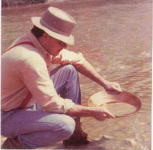
Many people enjoy prospecting and panning for gold in Alabama. The gold area of Alabama is laced with gold-bearing streams where prospecting and panning for gold is done as a delightful outdoor recreation. A good gift.
Treasure hunters with metal detectors do prospecting with their detectors in hopes of finding a gold nugget. Rockhounds and mineral collectors search for garnets and black tourmaline gem stones.
WHERE TO LOOK FOR AND FIND GOLD IN ALABAMA
Big Ten, Inc.'s Alabama Gold Prospecting and Panning Map shows places where to look to find gold near:
Alabaster, Alexander City, Anniston, Ashland, Auburn, Calera, Camp Hill, Carrville, Childersburg, Clanton, Columbiana, Cragford, Dadeville, Fort McClellan, Gold Hill, Goodwater, Heflin, Jordan Lake, Lake Mitchell, Lafayette, Lineville, Louina, Martin Lake, Mignon, Parkdale, Pell City, Prattville, Oxford, Red Hill, Roanoke, Rockford, Talladega, Talladega National Forest, Tallassee, Wadley, Wedowee and Wetumpka.
It shows one hundred forty (140) gold mines and prospecting and panning locations from official geological records of the State of Alabama and the federal government. Locations for finding gold are shown within 25 miles of each of the above listed places. These gold deposit locations, which show where gold has been found in the past, are clearly marked.
The map is done in color. The margin of the map has text that tells where to look for gold in a streambed, how to tell "fools gold" from real gold and gives step-by-step gold panning instructions. You can quickly learn to pan by following the instructions on the map.
Comments on Mining of Gold, Gold Prospecting, Gold Panning, Treasure Hunting and Rockhounding in Alabama
The gold prospecting and mining locations in Alabama start in Chilton County between Montgomery and Birmingham and continue to the east and northeast to the Alabama/Georgia state line. The gold panning, prospecting and mining sites then carry on into Georgia and thence on through the Carolinas to northern Virginia.
Gold prospecting and panning locations will be seen in the Talladega National Forest, the boundaries of which are shown on the Alabama Gold Prospecting and Panning Map.
Gold has also been found in Gold Branch, a creek in the northeast corner of Elmore county. Alabama Highway 229 crosses Gold Branch between Kent and Red Hill. Gold Branch flows into the Tallapoosa River about five miles downstream of the dam at Martin Lake. The deposit appears to be a continuation of the trend of gold mining sites shown along Martin Lake on the Alabama Gold Prospecting and Panning Map.
 Gold Panning |
Note: Gold historical information herein was obtained from research of geological records of the Alabama Geological Survey, the U. S. Bureau of Mines, the U.S. Geological Survey and similar documents as pertains to gold mines, gold prospecting and panning areas and mineral and gem stone occurrences in Alabama. Prior work by Thomas A. Simpson, Thornton L. Neathery and George I. Adams is acknowledged.
Alabama geological documents state that it is generally agreed by historians that the Indians and Spanish explorers did not find gold in Alabama. There is no way to confirm the exact year of discovery of gold in Alabama; however, it is accepted to have been about 1830.
After the gold discoveries in Georgia in 1828, gold prospectors expanded their search for gold into Alabama. Intruders prospected for gold on lands belonging to the Creek Indians, who held the area that included the gold deposits. A treaty was negotiated by the United States for the lands of the Creeks. The treaty was signed in 1832; but, before the removal of the Indians was accomplished, the state legislature formed the lands into counties and settlers flocked in.
Further research of gold history as recorded in geological reports, reveals that about 1836 there was a great deal of excitement in the gold fields of Alabama. One of the early gold districts, Arbacoochee, is said to have given employment to 600 men and in 1845 had a contributory population of 5,000 inhabitants. Goldville, another Alabama gold district, was said to have had 14 stores and the population in the locality was at least 3,000. Goldville later became a cross-roads without a store.
Most Alabama gold miners left the state to join the California Gold Rush in 1849. Gold prospecting and panning in Alabama revived when Cornish miners came from Tennessee in 1853-1854 to search for copper. There was another revival of gold mining in the 1880’s and cyaniding was introduced in Alabama in 1903.
Some Alabama gold mines were in operation at various times up to 1916. Another spurt in panning and prospecting for gold took place during the depression when people were out of work and the price of gold was increased to $35 per ounce. Gold pans and sluice boxes were widely used to recover gold from stream placers.
ALABAMA/SOUTH CAROLINA GOLD MAP
One hundred forty (140) gold mines and prospecting sites are
shown in Alabama. Gold mining in Alabama began in the 1830's and the hobby of
recreational gold prospecting and panning is enjoyed by many people today. A
geological report states: “The Hilton Brothers reopened the pit. They succeeded
in obtaining 65 ounces of gold from a hole 3 feet by 2 feet by 20 inches; the
result of half a day’s work.”
One hundred thirty (130) gold mines and prospecting sites are
shown in South Carolina. There were several operating gold mines in South
Carolina in recent years. Treasure hunters using metal detectors like to "gold
nugget shoot" in the gold areas and "coin shoot" at the rural schools and
churches shown.
To request gold maps please go to REQUESTING GOLD MAPS .
Copyright © 2019 H & H Engineering., All Rights Reserved.